ATTENTION CDT HIKERS- REROUTE IN EFFECT STARTING JULY 1
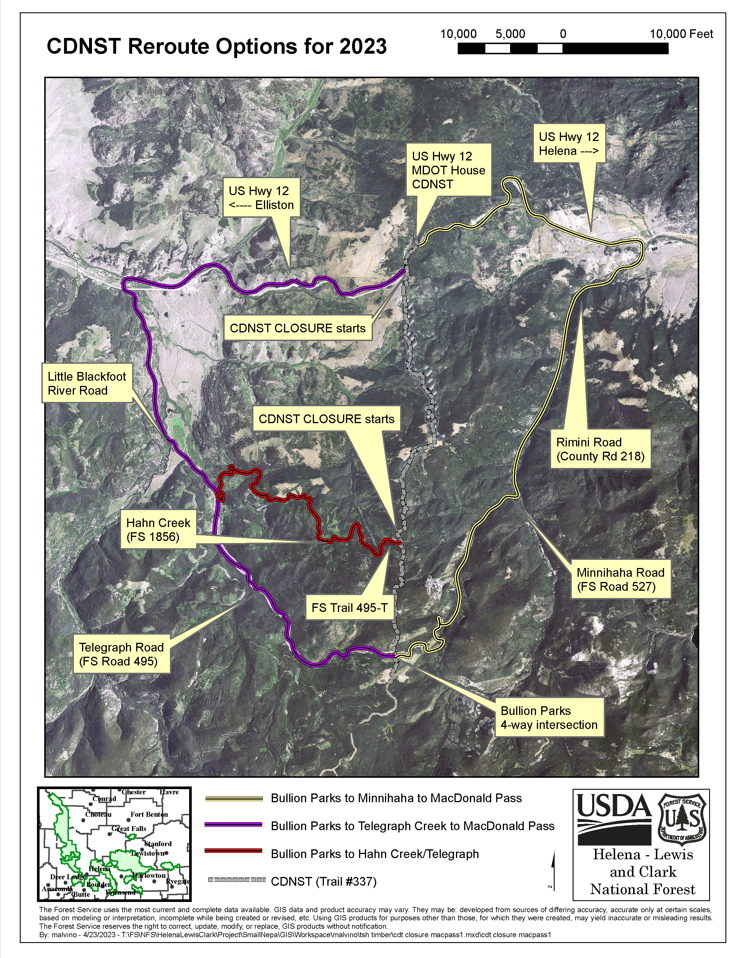
The Helena Ranger District is implementing a long-awaited fuel mitigation project during the summer of 2023. Almost five miles of the Continental Divide National Scenic Trail (CDT) is impacted and there will be a reroute of the CDT for public safety and to ensure the work is completed in as expeditiously as possible. The work involves heavy equipment operation and hazardous tree removal directly adjacent to the CDT. This work will create a safer trail for the public and firefighters in the event of a wildland fire. The project is part of the Tenmile – South Helena Project; the record of the decision was signed in 2018. The miles with the project area are CDNST Series 370 (MT-ID), section 20, miles 616.5 – 620. Please see attached reroute options and find which route best suits your needs.
Southbound
MacDonald Pass to Minnehaha to Bullion Parks (YELLOW LINE) – 15.8 miles; This is the most straightforward and shortest reroute of the three options. After arriving at US Hwy 12 near Montana Department of Transportation equipment garage, head east (downhill) on US Hwy 12 for 5.3 miles to the intersection of Rimini Road (County Road 218). Head south towards Rimini for approximately 5.5 miles to the intersection for Minnehaha Road (Forest Service Road 527). Head west on Minnehaha Road and stay on this main road for 5 miles to the intersection of Bullion Parks (Forest Service Road 1863). At this 4-way intersection, you are now back on the CDT. From this four-way intersection head south to continue your journey along the CDT (ForestService Trail 337/Forest Service Road 1863).
MacDonald Pass to Telegraph Creek to Bullion Parks (PURPLE LINE) – 16 miles; From the intersection with US Hwy 12 at Montana Department of Transportation equipment garage, head west on the Highway about 0.5 miles up and over MacDonald Pass. (On the south side of MacDonald Pass there is a developed campground called Cromwell-Dixon that boasts water and vault toilets.) Continue west on US Hwy 12 for 6.4 miles towards Elliston. The town of Elliston is small but does have a bar (the Spotted Dog Bar) offering a limited bar menu and cold drinks. The town of Elliston also has a small general store-gas station where limited supplies can be acquired. The store also offers a backyard where thru-hikers can pitch a tent and camp for the night. There is also a post office in town where resupplies can be delivered to. If there is no need to visit Elliston, then just before reaching Elliston (6.3 miles from MacDonald Pass) head south (turning left) along the Little Blackfoot River Road towards Telegraph Creek. At approximately 3 miles down the Little Blackfoot Road there is a Y-intersection where you will stay left (east) onto a dirt road (Forest Service Road 495). Stay on this main dirt road for about 6.7 miles to the 4-way intersection with Bullion Parks (Forest Service Road 1863). From this intersection head south and you are now back on the CDT which follows another road that is open to vehicle traffic (Forest Service Trail 337/Forest Service Road 1863).
Hanh Creek/Telegraph to Bullion Parks (RED LINE) – 19.1 miles; This is the longest but arguably the most scenic of the three reroute options. This reroute starts the same as the Telegraph reroute but veers off at mile 10.6. The route then follows a less-traveled dead-end logging road up Hahn Creek (Forest Service Road 1856). At 14.2 miles you will encounter a gate that permanently closes the road to all vehicle traffic. Travel on foot for another 2.3 miles beyond the gate to a trail heading east on Forest Service Trail 495-T. After another 0.4 miles, you are now back onto the CDT. Follow the CDT south for another 2.2 miles to the 4-way intersection with Minnehaha (Forest Service Road 527) and Telegraph (Forest Service Road 495) roads. Keep heading south at the 4-way intersection and you are officially back on track (Forest Service Trail 337/Forest Service Road 1863).
Northbound
Bullion Parks to Minnehaha to MacDonald Pass (YELLOW LINE) – 15.8 miles; From the 4-way intersection at Bullion Parks head east on the Minnehaha Road (Forest Service Road 527) for 5 miles to Rimini Road (County Road 218). Head north on Rimini Road for 5.5 miles to US Hwy 12. At US Hwy 12, head west along highway for 5.3 miles to the Montana Department of Transportation equipment garage where you will get back onto the CDT by going up the hill following Forest Service Road 1802.
Bullion Parks to Telegraph Creek to MacDonald Pass (PURPLE LINE) – 16 miles; From the 4-way intersection at Bullion Parks head west along a dirt road (Forest Service Road 495) towards the Little Blackfoot River for 6.7 miles to a Y-intersection. From the Y, stay right along Little Blackfoot River Road (paved) for 3 more miles to US Hwy 12. From US Hwy 12, head east along the highway for 6.3 miles up and over MacDonald Pass to the Montana Department of Transportation equipment garage where you will get back onto the CDT by going up the hill following Forest Service Road 1802.
Bullion Parks to Hahn Creek/Telegraph (RED LINE) – 19.1 miles; From the 4-way intersection at Bullion Parks, head north for 2.2 miles to an old jeep trail that heads west. Follow that trail for 0.4 miles to a decommissioned two-track. Head south (left) on the two-track (Forest Service Trail 495-T) for 5.9 miles to Telegraph Road (FS Road 495). At mile 2.3 along the two-track you will pass through a gate that gets you back onto a road open to vehicle traffic (FS Road 1856). From Telegraph Road head north (right) for 1.3 miles to a Y-intersection with Little Blackfoot River Road. Go right onto the paved road and follow the river downstream for 3 more miles to US Hwy 12. Head east along Hwy 12 for 6.27 miles up and over MacDonald pass to the MontanaDepartment of Transportation equipment garage where you will get back onto the CDT by going up the hill following Forest Service Road 1802.


