Closures and Alerts
CDTC posts up-to-date information as received regarding closures, restrictions, and other notices along the official route of the CDT here. Alerts are also posted to the r/CDT Reddit. If you have any information regarding new incidents, please let us know at [email protected].
Current Alerts and Closures
CDTC is committed to providing information concerning the Continental Divide Trail and pass updates to trail users from land management agencies. CDTC does not have governing authority or jurisdiction over lands adjacent to the CDT.
If you are in an emergency, call 911. If you witness or are involved a threatening or violent act, contact local law enforcement.
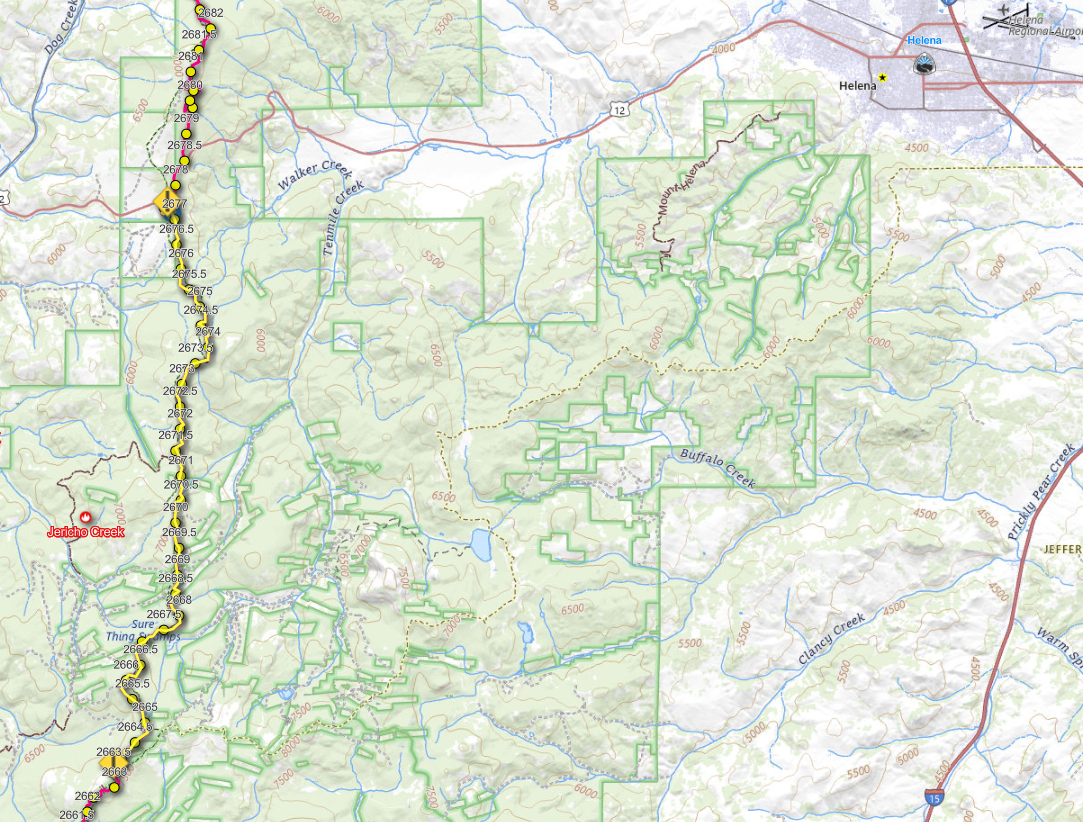
Jericho Creek Fire | Helena Lewis & Clark National Forest | CDT Miles 2664-2677.5 | 5/15/26
The Helena Lewis & Clark National Forest is asking people to avoid the area near the Jericho Creek Fire, which includes the CDT from approximately 2664-2677.5 (MacDonald Pass). There is no recommended reroute at this time. We will post more information as we receive it.
From Helena-Lewis & Clark National Forest Facebook Page:
Jericho Creek- Helena Ranger District. With high winds yesterday and overnight, the Jericho Creek Fire has grown to approximately 100 acres. Due to hazardous conditions including snags, heavy dead and down timber, and windy conditions, firefighters will continue to utilize an indirect confinement strategy. This will include conducting burnout operations today and utilizing containment lines and fuel breaks constructed during the 2025 Jericho Mountain Fire. Smoke will be visible during today’s burnout operations.
Resources assigned to the fire include four Type 6 Engines, one hotshot crew, one water tender, two suppression modules, a Unmanned Aircraft System (UAS) module, and a Type 2 Helicopter.
Moisture, including rain and snow, is predicted for this weekend which will help to moderate fire activity.
Firefighter and public safety is our number one priority. Please avoid the area around the Sally Ann Mineral Site and the Continental Divide Trail.
CDT Closed Until Further Notice Due to Bear Encounter, Hikers Injured | Yellowstone NP | CDT Miles 2033-2039
On the afternoon of May 4, two hikers sustained injuries by one or more bears on the Mystic Falls Trail near Old Faithful in Yellowstone National Park. The National Park Service has issued temporary closures pending completion of their investigation. The Summit Lake Trail, which carries the CDT, is closed within the affected area.
No reroute information is available at this time. Hikers should plan to avoid the closure area entirely until the National Park Service lifts the closure.
Stay safe in bear country:
- Stay 100 yards away from bears at all times
- Carry bear spray and know how to use it
- Be alert; watch for fresh tracks, scat, and feeding sites
- Make noise on the trail
- Hike in groups of three or more people
- Avoid hiking at dawn, dusk, or at night, when grizzlies are most active
- Do not run from a bear
- Learn more about bear safety on the CDT here.
View the closure area on the CDT Interactive Map.
For full details and a closure map, see the official NPS press release.
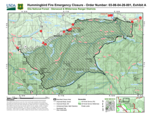
Hummingbird Fire Closure | Gila National Forest | Gila Alternate Portions Closed | Updated 4/25/26
For those taking the Gila alternate, the Middle Fork trail is closed from Snow Lake to Clayton Creek (Farout Gila Alternate mile 74-77.6) due to the Hummingbird Fire.
Hikers can detour around the closure utilizing the Aeroplane Mesa Trail (alternate junction mile 70.7) and Loco Mountain Road, to connect back with the Gila alternate north of Snow Lake (alternate mile 79.2).
For more information please contact [email protected]
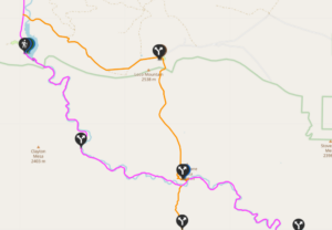
Recommended detour is in orange:
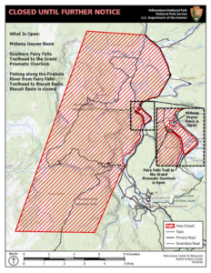
Biscuit Basin Reroute | Yellowstone NP | Mile 2033.5-2034 - Updated 7/7/25
On Tuesday, July 23, at about 10:19 a.m., a localized hydrothermal explosion occurred near Sapphire Pool in Biscuit Basin, located just north of Old Faithful.
- Biscuit Basin, including the parking lot and boardwalks, are closed for the 2025 season. The Grand Loop Road remains open.
- The Park Service is recommending hikers utilize the Upper Geyser Basin (UGB) Biscuit Basin Trail as a reroute option as shown below in blue.
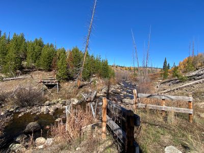
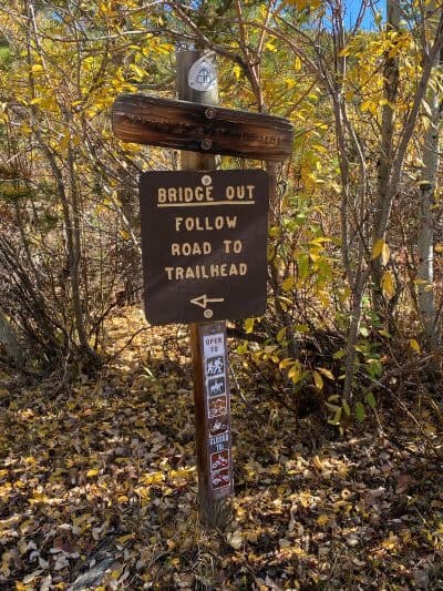
Bridge Out - Diamond Park Detour | Routt National Forest | Mile 1516.5-1518 | Updated 10/17/25
The footbridge across North Fork Elk Creek is out in the Routt National Forest. The USFS is recommending a short 1.5 mile detour to the west following Stiletto Rd and the Main Fork Trail.
Northbound
- Take Stiletto Rd west from the CDT crossing of Stiletto Rd (mile 1516.5)
- Continue north on Stiletto Rd until you reach the Diamond Park North Trailhead
- Take the Main Fork Trail north until you meet back with the CDT at mile 1518
Southbound
- Exit the CDT at the Main Fork Trail junction at mile 1518
- Continue south on the Main Fork Trail until you reach the Diamond Park North Trailhead
- Take Stiletto Rd south until you reach the CDT crossing of Stiletto Rd (mile 1516.5)
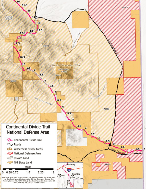
Southern Terminus Restricted Access | Mile 0.0 - 1.1 | Updated 3/18/26
Access to the CDT Southern Terminus is now restricted due to the establishment of the New Mexico National Defense Area (NDA) along the US-Mexico Border
Update: 3/18/26
Since the designation of the National Defense Area (NDA) at the southern terminus of the Continental Divide National Scenic Trail, CDTC has been working closely with the U.S. Army at Fort Huachuca, federal agencies, and elected officials to address and advocate for access to the CDT.
These efforts have resulted in the following updates regarding access to the CDT and its southern terminus:
- Anyone desiring access to the southernmost 1.1 miles of the CDT is required to obtain a free NDA pass. US citizens and non-US citizens are able to apply. Click here to apply.
- Non-US citizens may be issued a Temporary Visitors Pass, which requires an escort at all times while in the NDA.
- Any US citizen who has received an NDA access pass may serve as an escort to non-US citizens with a Temporary Visitor’s Pass. Escorts do not need to have additional Department of Defense clearance.
- The CDTC shuttle is now able to drive all riders with an NDA Access Pass, or Temporary Visitor’s Pass with appropriate escort, directly to the southern terminus monument. We will still stop at CDT mile 2.2 to drop off anyone without an NDA Pass or anyone who does not want to enter the NDA.
- The access roads to the southern terminus remain open at this time, however, this is a dynamic situation due to construction of the Southern Border Wall. Road closures are anticipated in the future as construction begins. We will communicate any road closures as they happen via our alerts page.
- Expect higher traffic including heavy construction vehicles along Commodore Road. Delays are possible. Hikers opting to walk Commodore Rd, instead of the CDT, should use caution.
- Applications generaly take 48 hours to process, but we recommend applying well in advance in case you experience delays. Once granted, a digital access badge or Termpory Visitor’s Pass will be emailed to you from the U.S. Army at Fort Huachuca
I am an international hiker with a Temporary Visitor’s Pass. How do I find an NDA escort?
If you are taking the CDTC shuttle, you may pair with a US citizen with NDA clearance during shuttle check-in the morning of your ride.
CDTC Southern Terminus Shuttle
CDTC is still operating an on-demand shuttle and water caching service with drop/off pickups at the southern terminus monument and outside the NDA at CDT mile 2.2.
For shuttle information and booking please visit this page.
For more information please call 719-749-1234 or email [email protected]
Fire Restrictions
Fire restrictions for lands the CDT passes through are listed roughly south-to-north by state.
| Location | State | CDT Mile | Type | Updated Date |
| New Mexico State Lands | New Mexico | Various locations throughout the entire state | Open Fire Restrictions | 4/6/26 |
| Arapaho NF | Colorado | 1261-1342 | Stage 1 | 3/30/26 |
| Pike-San Isabel National Forest | Colorado | 1068-1201 | Stage 1 | 3/27/26 |
| Carson National Forest | New Mexico | 692-794.5 | Stage 1 | 4/23/26 |
| Santa Fe National Forest | New Mexico | 647-696 | Stage 1 | 4/2/26 |
| Cibola National Forest | New Mexico | 539-584 | Stage 1 | 5/7/26 |
| Gila National Forest | New Mexico | 98-403 | Stage 1 | 3/20/26 |
Past Alerts
Trout Fire - Now Open | Gila NF | Mile 182 - 204.5 | Updated 8/1
The Trout Fire was 100% contained on July 24 and the associated area closure was lifted as of Thursday, July 31. The public should be aware of hazards that exist within the burned area, including stump holes and loosened soil, rolling rocks, logs, and other debris, fire-weakened trees, and roads or trails that may be impassable due to fallen trees or flood impacts. There is potential for flash flooding within the burned area, especially where soil and vegetation burned at higher intensity.
Jericho Mountain Fire - Now Open | Helena L&C NF | Mile 2663.5 - 2677 | Updated 7/10
Update 7/10:
Jericho Mountain Fire Closure is now rescinded. Closure Order Number 01_15_12_25_11 has been rescinded as of 07-10-2025. The closure order was lifted for all roads and trails, including the Continental Divide Trail. Use caution near or in burned area due to unstable surfaces and fire weakened trees.
Reroute:
Jericho Fire CDT reroute map and directions
For more info: Inciweb
Buck Fire - Now open | BLM Socorro | Mile 291.5-332.5 | Updated 7/11
The CDT has reopened from the Buck fire (New Mexico BLM Socorro district: mile 291.5-332.5). Please be aware of potential post fire hazards and navigation challenges.
For more info: InciWeb