Colorado packs more 14,000-foot peaks than any other state, and the Continental Divide Trail (CDT) spends roughly 740 miles winding right through the thick of them. So it surprises a lot of people to learn that the Trail deliberately steps around nearly every summit. Walk the whole Colorado section and you’ll cross only one true 14er on the official route.
That’s not an oversight. It’s by design, and once you understand why, the handful of 14ers you can reach from the CDT become a lot more meaningful. This guide walks through every Colorado fourteener that sits on the Trail, on the Continental Divide itself, or close enough to bag as a half-day side trip. We’ll also clear up a few peaks that look close on a map but really aren’t, because knowing the difference is half the fun.
Whether you’re planning a CDT thru-hike, a section hike, or just curious about the high country you love, here’s how the CDT and Colorado’s 14ers actually fit together.
The Continental Divide vs. the Continental Divide Trail
These two things share a name, but they’re not the same — and the difference is the key to this whole guide.
The Continental Divide is a geographic feature: the watershed line running down the spine of the Rockies that decides where water goes. Rain that falls on the west side eventually reaches the Pacific; rain on the east side heads toward the Atlantic. It’s an invisible line along the highest ridges, and it crosses dozens of summits.
The Continental Divide Trail is a footpath. It follows the spirit of that line for 3,100 miles from Mexico to Canada, but it doesn’t cling to every high point. Through Colorado, the Trail often contours just below the ridgeline rather than tagging each peak. There are good reasons for that: staying off fragile summit tundra protects the landscape, gentler grades are safer and more sustainable for all the people and stock who travel the Trail, and the CDT was never meant to be a peak-bagging route in the first place. It’s a journey along the Divide, not a checklist of its summits.
Here’s the fact that captures it: of the hundreds of ranked peaks sitting directly on the Continental Divide in Colorado, only two are 14ers — Grays Peak and Torreys Peak. Plenty of other famous fourteeners rise close to the Trail or the Divide, but “close” and “on” are different things. We’ll keep that distinction front and center.
The highest point on the CDT: Grays Peak

If you climb just one 14er that the Trail itself crosses, this is it — because it’s the only one.
At 14,278 feet, Grays Peak is the highest point on the entire Continental Divide Trail, and the highest point on any National Scenic Trail in the country. It’s also one of the few places where the Trail and the physical Divide reach their high point together.
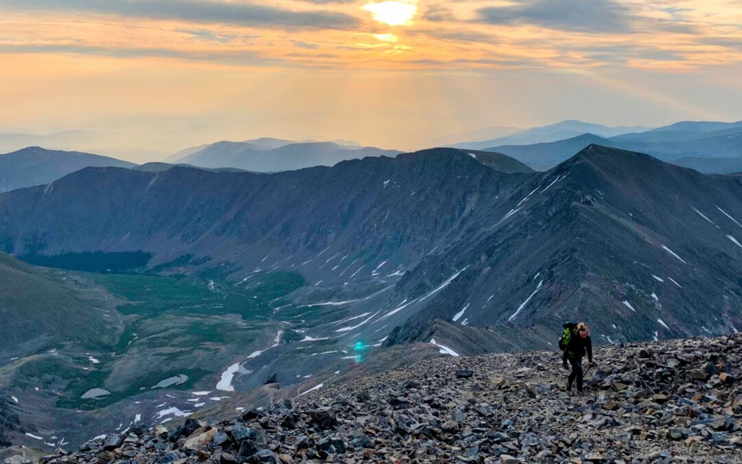
Grays sits in the Front Range, and the CDT climbs to its summit along the ridge from Argentine Pass, traversing 13,850-foot Mount Edwards on the way — a stretch of Class 2 ridgeline with serious above-treeline exposure. Most day hikers, though, take the standard Class 1 trail from the Stevens Gulch trailhead near Bakerville: roughly 8 miles round trip with about 3,000 feet of gain.
From the top you’re standing on the watershed of the continent, with views spilling east toward the plains and west across a sea of peaks. Mountain goats are a common sight. Just be ready for company — Grays is one of the most popular 14ers in the state thanks to its closeness to Denver, so an early start pays off.
Don’t forget Torreys. Grays has a twin. Torreys Peak (14,275 feet) sits just 0.7 mile away across a saddle, and it’s also right on the Continental Divide. Drop off Grays’ north side and climb back up, and you’ve bagged two of Colorado’s only on-Divide 14ers in a single outing. The Grays–Torreys saddle is one of the most photographed stretches of the whole CDT, and for good reason.
The thru-hiker's 14er: San Luis Peak

Ask a CDT thru-hiker which 14er they actually summited, and odds are they’ll say San Luis.
Tucked into the heart of the La Garita Wilderness, San Luis Peak (14,014 feet) is the easternmost fourteener in the San Juan Mountains — and the easiest, most accessible 14er on the whole Colorado CDT. Unlike the others, you barely have to leave the Trail to get it.
The CDT (running together with the Colorado Trail through here) crosses a saddle on San Luis’s south ridge. From there, the spur to the summit is only about 1.5 miles of climbing — call it a short round-trip detour by 14er standards. The whole thing is Class 1: a straightforward walk-up on a well-built trail, no scrambling required. For a hiker already deep into a long day, that’s an easy “yes.”
San Luis is a broad, gentle, grassy giant in one of the most remote corners of the state. You may well have the summit to yourself — a rare gift on a Colorado 14er. It’s also a peak that’s seen real stewardship love: trail crews have rerouted the path here over the years to protect rare alpine plants and the fragile banks of Stewart Creek, a good reminder that even the quiet peaks need care.
Sawatch side trips: 4 giants within reach of the Trail
The Sawatch Range is where Colorado stacks its biggest mountains, and the CDT (here following the Colorado Trail’s Collegiate West route) threads right past several of them. Eight fourteeners rise within four miles of the Trail in this stretch. None of them sit on the Trail or the Divide — the watershed line actually runs west of these peaks — but four are realistic half-day side trips for a hiker willing to take a detour. Here they are, roughly in order of how achievable they are.
Mount Elbert — the roof of Colorado (and no, it's not on the Divide)

At 14,438 feet, Mount Elbert is the highest peak in Colorado and the second-highest in the Lower 48. It’s also the subject of a stubborn myth: lots of people assume the highest point in the state must sit on the Continental Divide. It doesn’t. Elbert drains east toward the Arkansas River, which puts it firmly on the Atlantic side — near the Trail, but not on the Divide.
Near, though, is the operative word. The CDT and Colorado Trail run together below Elbert near Twin Lakes, and a signed junction puts the summit roughly 3.3 miles away via the Class 1 Northeast Ridge. For a thru-hiker willing to take a side trip — or anyone basing themselves in Leadville or Twin Lakes — Colorado’s high point is genuinely within reach. It’s a “gentle giant”: a long, walk-up summit with a couple of false tops to keep you honest and a 360-degree payoff at the end.
Huron Peak — the closest 14er to the Trail

If you want the 14er nearest to the official CDT, it’s Huron Peak (14,006 feet). From the Trail junction in the Three Apostles area, it’s about 2.9 miles to the summit on a Class 1 trail with a short Class 2 finish.
Huron is a hiker favorite for one big reason: the view. The summit looks straight across at the jagged Three Apostles — Ice Mountain, North Apostle, and West Apostle — in what many consider the finest panorama in the Sawatch. The approach winds past the historic Vicksburg and Winfield mining sites and through wildflower meadows. For a CDT hiker, it’s arguably the most rewarding side trip per mile in the whole range.
Mount Massive — the most mountain in the Lower 48

Mount Massive (14,427 feet) is Colorado’s second-highest peak, and it earns its name: its summit ridge runs for miles, giving it more terrain above 14,000 feet than any other mountain in the contiguous United States. From the CDT/Colorado Trail near Willow Creek, the East Slopes route reaches the top in about 3.7 miles. It tends to be quieter than its famous neighbor Elbert, which for some hikers is the whole appeal.
La Plata Peak — the ambitious one

La Plata Peak (14,336 feet) is the fifth-highest in the state and the most demanding of these four. Its standard Northwest Ridge route is Class 2, with talus scrambling near the top, and the standard climb runs 9.25 miles round trip with 4,500 feet of gain. Many thru-hikers tackle it as an overnight rather than a quick detour. The reward is a sharp, dramatic peak rising straight out of the Lake Creek valley. The name is Spanish for “silver,” a nod to the area’s 1870s mining history.
Bonus peaks: the Collegiate East alternate
Many CDT hikers swap the official Collegiate West route for the popular Collegiate East alternate (the original Colorado Trail). It’s worth knowing that the East route is not the designated CDT — but it does open the door to a cluster of additional 14ers. If your hike takes you that way, here’s the quick rundown.
| Peak | Elevation | Standard route | Notes |
|---|---|---|---|
| Mount Yale | 14,196 ft | Class 2 | Trailhead near Buena Vista |
| Mount Princeton | 14,197 ft | Class 2 | Iconic profile above the valley |
| Mount Antero | 14,269 ft | Class 2 | Long jeep-road approach |
| Mount Shavano | 14,229 ft | Class 2 | Often paired with Tabeguache |
| Tabeguache Peak | 14,155 ft | Class 2 | Named for the Tabeguache Ute band |
| Mount Harvard | 14,424 ft | Class 2 | Long approach; usually an overnight |
| Mount Columbia | 14,073 ft | Class 2 | Frequently paired with Harvard |
All of these peaks sit within the Collegiate Peaks Wilderness on the ancestral lands of the Núuchi-u (Ute) people.
Famous 14ers near the Divide — but not the Trail
Part of understanding the CDT is knowing what isn’t on it. A few of Colorado’s most famous fourteeners sit tantalizingly close to the Trail or the Divide, but don’t quite qualify. Here’s why.
- The DeCaLiBron peaks (Democrat, Cameron, Lincoln, and Bross). The Continental Divide really does run through this area — it crosses the Mosquito Range from Hoosier Pass over to Fremont Pass. But the Divide passes just north of these four summits, which all sit on the Atlantic side. And the CDT itself is miles away, over in the Tenmile Range. Close to the Divide, but not on it — and not on the Trail.
- Quandary Peak. The Tenmile Range’s only 14er is visible from much of the CDT near Breckenridge and Copper Mountain, but its trailhead at Hoosier Pass is a real haul from the Trail.
- Mount of the Holy Cross. It looks close on a map, but the CDT only brushes the far corner of the Holy Cross Wilderness, on the opposite side of the Divide from the peak. The standard route is more than ten miles from the Trail.
- The Chicago Basin trio (Eolus, Sunlight, and Windom). The CDT runs for miles through the Weminuche Wilderness, but these three are reached from a train stop and a long climb in — well off the Trail.
- Longs Peak and the northern 14ers. The official CDT bypasses Rocky Mountain National Park on its west side, leaving Longs out of reach. North of Interstate 70, there are no 14ers along the Trail at all.
Climbing 14ers on the CDT, responsibly

A 14er side trip is a thrill — and these summits need our care to stay that way. Colorado’s high peaks hold rare alpine tundra that exists almost nowhere else, and it’s slow to recover when it’s trampled. The Colorado Fourteeners Initiative estimates these peaks see around 265,000 hiker-use-days a year, and in many places the wear is past the point of natural recovery. A few simple habits go a long way:
- Stay on the trail, even when it’s muddy or snowy. One footstep off the tread can crush plants that took decades to grow.
- Plan around the weather. Afternoon thunderstorms roll in fast up high. Aim to be off the summit by noon, and don’t be afraid to turn around — the peak will be there next year.
- Respect the altitude. These side trips climb thousands of feet above an already-high Trail. Go slow, drink water, and know the signs of altitude sickness.
- Pack it in, pack it out, and follow Leave No Trace from trailhead to summit and back.
The CDT travels through some of the darkest night skies left in the country, too. If you camp near these peaks, you’re in for a show — and you can help keep it that way. Learn more about the dark night skies of the CDT.
Frequently asked questions
Does the CDT summit any 14ers? Yes, one. Grays Peak (14,278 feet) is the only 14er the official Continental Divide Trail crosses in Colorado, and it is the highest point on the entire Trail. Its twin, Torreys Peak, is a short side trip away.
What is the highest point on the Continental Divide Trail? Grays Peak, at 14,278 feet, is the highest point on the CDT and on any National Scenic Trail in the United States.
What is the easiest 14er to climb on the CDT? San Luis Peak in the La Garita Wilderness. It is a Class 1 walk-up and only about a 1.5-mile spur off the Trail, which makes it the most popular 14er among CDT thru-hikers.
Is Mount Elbert on the Continental Divide? No. Despite being the highest peak in Colorado, Mount Elbert sits east of the Divide and drains toward the Atlantic. The CDT passes near it, but the watershed line runs to the west.
How many 14ers are on the Continental Divide in Colorado? Just two: Grays Peak and Torreys Peak. Many other 14ers rise near the Divide or the Trail, but only these two sit directly on the watershed line.
Your turn on the Divide

The CDT’s relationship with Colorado’s 14ers is really a lesson in what the Trail is about. It’s not a race to the top of every peak — it’s a long, humbling walk along the backbone of the continent, with a few summits close enough to tempt you off-route along the way. Grays for the milestone, San Luis for the thru-hiker rite of passage, Elbert or Huron for the bucket-list bag — each one is a chance to stand a little higher on the Divide we all share.
However you experience the Trail, we’re glad you’re here for it. If this guide helped you plan, consider helping us protect the places it leads.
- Start planning with the CDT Planning Guide.
- Explore more day and section hikes and CDT maps and data.
- Help protect the Trail: donate or volunteer.